Is it possible to detect buried PE pipes from the surface?
Yes. Methods have been developed for detecting buried PE pipes from the surface but each has its limitations which need to be understood when deciding which to use.
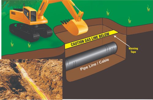
The simplest method of detecting PE pipe is when laying the pipe to provide a tracer wire along the pipe route. The tracer wire can also be incorporated into marker tape, which is laid above the pipeline during construction. The tracer wire can then be detected above ground by conventional electromagnetic pipe detection equipment via induction techniques or direct connection from inspection chambers, valve locations or above ground connection points, associated to marker posts.

.png)
Example of marker tape Example of tracer wire
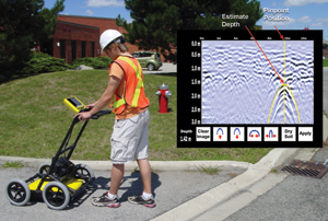
Ground probing radar (GPR) has been developed specifically for locating small objects at relatively shallow depths. Used properly GPR can be effective in detecting buried PE pipes through collecting transects perpendicular to the assumed direction of the PE pipe. However, GPR relies on material property contrasts, and therefore cannot differentiate between and detect all underground objects. The GPR signal (reflection of the radar wave) can be subject to overprinting in congested areas, reducing the capability of uniquely identifying a single pipe. Finally, in soils with high electrical conductivity (clays or highly saturated material) the signal strength is attenuated rapidly, reducing the depth of detection greatly. Although operation of a GPR system is relatively straightforward, the interpretation often requires a skilled and experienced person to identify individual features. For larger objects a range of more sophisticated geophysical detection techniques (Electromagnetic induction, Time Domain EM, Magnetic surveys etc) have been developed or adapted from other applications. As with all geophysical techniques, they map contrasts of physical properties, which can vary between soil types and material of the pipe under investigation. In the right conditions, and when data is interpreted by an experienced person they can be very successful.

GPR Survey to locate buried utilities
Good practice in underground utility location is to use more than one independent method and to compare/correlate their results to create a single deliverable. For example the UK PAS128 Specification for underground utility location and detection identifies 4 levels of survey:
Type D: Desktop Utility Record Search. A thorough desktop search of all statutory asset owners to supply their record data.
Type C: Underground utility plotted from utility record data only, but with site reconnaissance to match utility record with physical utility street furniture as a best fit.
Type B: An on-site utility mapping survey using multiple geophysical instruments. The output from this survey shall be each linear 5 metre section of utility depicted as a Quality Level (QL) 1-4 for horizontal and vertical detection accuracy.
Type A: Utility verified and positioned by physical identification. This may be by strategically positioned vacuum excavation, hand dug trial pitting or by visual inspection within a utility chamber.
Related keywords : plastic pipe tracer, plastic pipe detector, underground pipe detector, how to detect plastic water pipes, how to locate underground pipes, marker tape with tracer wire, possible pe, how to locate pvc pipe underground, wire pipe detector, tracing water pipes underground, how to trace underground water pipes, how to find underground pipes, pvc pipe locator equipment, tracer wire for water pipes, plastic water pipe detector, gpr pipe, underground water pipe detector

